
Franklin’s Native Artifacts Include ‘Indian Mortar'
By Thomas P. Caldwell
Or if the Smiling Spirit
Should beckon from the lake,
Up Willow Hill ascending,
Your happy way you'll take,
And pass the old stone mortar
Where squaws first ground their corn
It stands and waits in silence
Quite forlorn.
— Passage from Alice Shepard’s poem “Franklin”
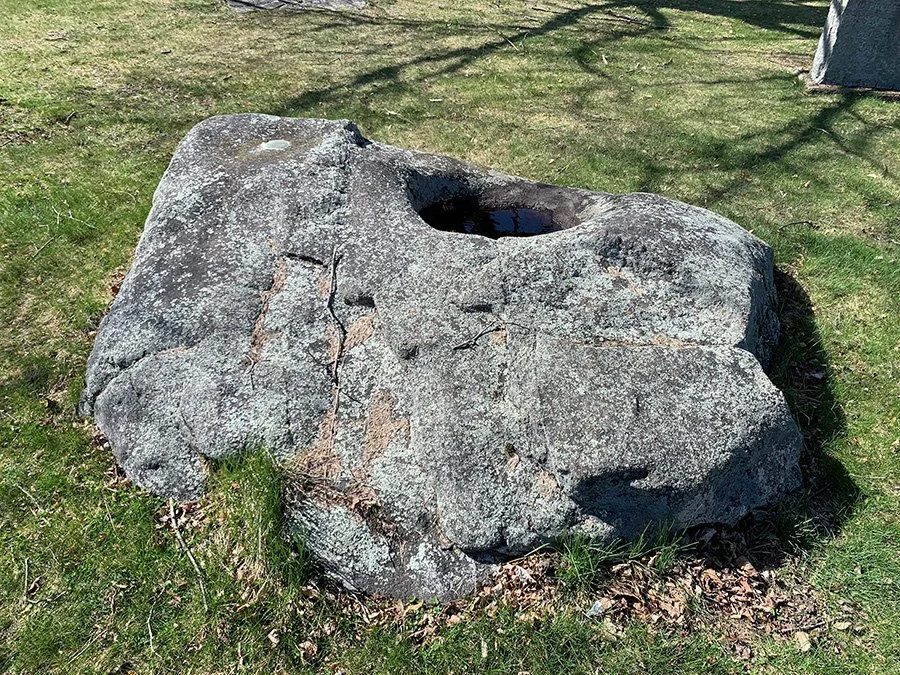
Atop Willow Hill in the city of Franklin lies what at first glance appears to be a simple granite boulder. A closer look — most likely because of having seen the nearby historical marker or monument — makes it apparent that the depression in the boulder was not simply something carved by wind and rain. It purportedly served as a grinding stone for the Abenaki inhabitants and later European settlers who crushed corn into meal on its hard surface.
The official New Hampshire historical marker, installed in 1979, states that the Indian Mortar was a glacial rock, shaped first by water and then by the grinding of corn from both Native and settler hands. It also mentions another boulder nearby that carries a carving of a shad, “carved, perhaps, by the red man to preserve a likeness of his favorite fish, which swam up the Winnipesaukee River when the shadbush blossomed.”
Like many accounts of the native inhabitants, the origins of the so-called Indian Mortar are not clear. Franklin historian Albert Garneau believed the boulder was already on the site at the intersection of Central and Dearborn streets when lots were laid out in what at the time was part of the town of Sanbornton. (Today’s city of Franklin, named after Benjamin Franklin, was created from portions of Sanbornton, Salisbury, Andover, and Northfield.)
The mortar lot was deeded to the Franklin Woman’s Club on September 26, 1904, and in 1927, a monument was placed on the site, stating, “This lot contains the ancient stone mortar used by Abenaki Indians and pioneer settlers of Sanbornton presented to Franklin Woman’s Club by descendants of James Clark Esquire.”
Joseph Clark was the original owner of two lots comprising 400 acres that included the mortar site, and James was his grandson. It was James’ granddaughter, Mary W. Clark, along with Enoch Bancker of Jackson MI, who as the executors of Charles H. Clark’s estate deeded the Indian Mortar lot to the Woman’s Club.
The club added a millstone to the lot, with the Journal Transcript reporting that it had come from Johnson’s Grist Mill of Webster Street on Chance Pond Brook. Records provided to Garneau by the Franklin Woman’s Club told a different story, saying the millstone came from the Pemigewasset River.

The shad fish stone referenced by the state marker had been discovered by Frank Proctor while on a relic-hunting expedition in 1921, according to his sister, Mary Proctor, who wrote about it in her “Indians of the Winnipesaukee and Pemigewasset Valleys”. Frank found the boulder on Meadow Brook, which runs into the Winnipesaukee River.
“On this boulder,” Mary Proctor wrote, “was pictured — I might truthfully say sculptured — a perfect shad! It was done by the skillful fingers of a red man. It may be some boastful fisherman who, lacking the modern camera, desired to preserve a likeness of his champion fish for all time. At any rate, this pictured rock tells a story of the days when the bony shad came up our river, at the time the shadbush blossomed, in such numbers that the inhabitants had hard work to take care of them.”
It was not until 1933 that the Fish and Game Association, which built a rearing pool on a dammed section of the brook, came across the find.
“After the Fish and Game Association finished their project, they found that large birds were landing on a rock that projected above the water and were eating the small fish,” Garneau wrote in his Official History of Franklin, New Hampshire. “When they examined the rock closely, they found that this was the boulder with the carved shad fish on it.”
The Franklin Highway Department subsequently moved the 1,500-pound rock to the Indian Mortar lot.
Frank Proctor’s relic-hunting expeditions in the Franklin-Tilton area led to a large collection of native artifacts that now reside at Dartmouth College’s Hood Museum. Professor Jere Daniell II, who had Franklin connections, assisted in establishing Dartmouth’s Native American Program.

New Hampshire’s indigenous population lived in bark-and-skin wigwams but ranged the forests, hunting and fishing while their women cultivated crops such as maize, beans, squash, and pumpkins. The Indian Mortar is believe to be a remnant of that tradition, allowing them to pound corn into hominy which, mixed with beans, yielded succotash.
Hunters used the bow, spear, and a log trap known as a “culheag” and they caught fish at weirs — nets created from wooden branches — and by spearing them. They would relocate with the seasons, as Mary Proctor wrote in her account.
“The shad and salmon in their spring migration [up the Merrimack River] always parted company at the junction of the two rivers,” she wrote. “The salmon followed the clear, cool waters of the Pemigwasset up to its mountain sources, while the shad liked the warmer water of the Winnipesaukee and the Lake.”
The indigenous people moved around based on those seasonal resources, and they referred to the two rivers joining to form the Merrimack as “the Crotch” — the three-river area that became known as Stevenstown, then Salisbury, and, finally, Franklin.
Other local histories touch upon the native population that once gathered in the area. Richard Musgrove’s History of Bristol mentions the artifacts found near Whittemore Point on Newfound Lake and at the Fowler River. There once were several lakeside campsites around Newfound, as well as at Profile Falls on the Smith River which feeds into the Pemigewasset, and at a spring in Old Hill Village.
The campsites were connected by “Indian trails”, including the Pemigewasset and Pass-aqua-nik (Pasquaney) trails which joined the Mascoma trail along the Smith River to Danbury and Lebanon. The Kancamagus trail joined the Pemigewasset trail at Woodstock, and the Asquamchumaukee trail joined it at an old village site near the mouth of the Baker River, just above Plymouth.
The Indians taught the European colonists to develop the fishing, hunting, and farming skills necessary to survive in New England, and the relationship was amicable for many years. As the colonists claimed more of the land as their homesteads, that relationship became fraught, and Franklin become one of the sites of violent conflicts before the original inhabitants disappeared, leaving behind the archaeological relics for museums and the items such as Franklin’s Indian Mortar.